Science News by AGU

The 14 August 2023 landslides in Himachal Pradesh, India
Share this:.
- Click to print (Opens in new window)
- Click to email a link to a friend (Opens in new window)
- Click to share on Twitter (Opens in new window)
- Click to share on Facebook (Opens in new window)
- Click to share on LinkedIn (Opens in new window)
The Landslide Blog is written by Dave Petley, who is widely recognized as a world leader in the study and management of landslides.

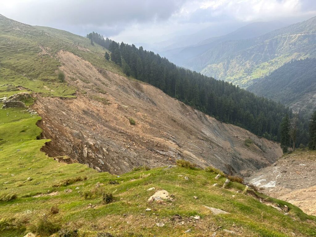
On 14 August 2023 extremely heavy rainfall affected the north Indian state of Himachal Pradesh, bringing widespread destruction. To date it is known that at least 58 people have been killed in flooding and landslides , but this may well increase further.
The most serious event appears to have occurred in the Shiva Temple in the Summer Hill area of Shimla in Himachal Pradesh, where a landslide struck a complex that was packed with worshipers. At least 10 people were killed, but up to 20 more may be buried in the debris. Rescue operations have been severely hampered by further rainfall. A further five people were killed nearby at Fagli.
Journalist Naveen S Garewal tweeted this image of the aftermath :-
Nine people have lost their lives, and more are trapped inside Shiv Mandir in Shimla’s Summer Hill after the temple structure collapsed due to heavy rainfall #Shimla #shivmandir #rainfall #Himachal #HimachalFloods #HimachalPradeshRains pic.twitter.com/Fa4jXeGKJ7 — Naveen S Garewal (@naveengarewal) August 14, 2023
Meanwhile, a further landslide destroyed a substantial section of the Shimla-Kalka railway line, a UNESCO world heritage line, near to Summer Hill. Freelance journalist Saurabh Chauhan tweeted some images of the aftermath :-
The track has been damaged in a number of other locations.
In Solan district, also in Himachal Pradesh, there are reports of a landslide that killed seven members of a single family in Jadon in Kandaghat subdivision. At least four other people were killed in the district, including two children at Balera and a woman at Banal in Ramsheher tehsil.
There are also reports of a single fatality in a landslide in the Rangas area of Hamirpur, whilst in Seghli in Mandi district, seven people were killed in a landslide. It is likely that there were other fatalities in landslides across Himachal Pradesh.
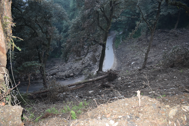
Meanwhile, the same rainfall has also caused substantial issues in the western part of Nepal. Obtaining good information from this area is very challenging, but there are reports of an intriguing landslide on the Kali Gandaki river. ICIMOD has tweeted about a valley blocking landslide , and subsequent flood, which appears to have caused substantial damage. There are also videos of the subsequent flood :-
The village of Kagbeni in Mustang was substantially damaged, but the location of the landslide is unclear.
The most intense part of the monsoon in South Asia continues to affect the western part of the Himalayas, such as Himachal Pradesh and Uttarakhand, with much less rainfall in the east. Indeed, some parts of north India are currently suffering a substantial rainfall deficit .
The eastern Himalayas typically get lower monsoon rainfall than the west. Landslides are typically triggered by large variations from the normal level of rainfall for that location, rather than absolute rainfall totals (in other words, 100 mm in 24 hours would trigger extensive landslides in the UK but would be unlikely to trigger any in Taiwan), explaining why these rainfall events are causing so many problems.
But of course underpinning all of this is the impact of poor quality development, such in inadequately engineered roads, which has made the landscape so much more vulnerable.
Text © 2023. The authors. CC BY-NC-ND 3.0 Except where otherwise noted, images are subject to copyright. Any reuse without express permission from the copyright owner is prohibited.
Features from agu publications, tiny satellites can provide significant information about space, a powerful new model for u.s. climate–air quality interactions, reflecting on 5 years at the helm of jgr: planets.
- May 17, 2024
- The ISPRS Foundation
International Society for Photogrammetry and Remote Sensing Internationale Gesellschaft für Photogrammetrie und Fernerkundung Société Internationale de Photogrammétrie et de Télédétection
- Article (22457 KB)
- Metadata XML

- Related articles
ANALYSIS OF LANDSLIDE REACTIVATION USING SATELLITE DATA: A CASE STUDY OF KOTRUPI LANDSLIDE, MANDI, HIMACHAL PRADESH, INDIA
N. singh, s. k. gupta, d. p. shukla.
Keywords: Temporal Change detection, Reactivated Landslide, Kotrupi (HP), Google Earth, Geomorphological Analysis, Remote Sensing
Abstract. Landslide is a global natural hazard that occurs frequently in the areas of incompetent weak rocks, undulating topography, steep slopes and incessant rainfall. In the night of 12 August 2017, a massive landslide took place at Kotrupi, Mandi district, Himachal Pradesh, India. The slide was so huge that it eroded more than 300-meter stretch of NH-154 killing over 50 people with more than 40 missing. Local residents report that this area has always been unstable where small landslides had occurred in the past. The landslide scar could be seen on the past satellite images from December 2001 to March 2017 on Google Earth. A huge landslide occurred at this location on 13 August 1977. After two decades on 13 August 1997, the landslide reactivated and some part of the slope failed, which can be seen on satellite images of the year 2001. The landslide reactivated again on 13 August 2007, but not much attention was given to it, as it was a small event and did not affect much. Again, after a decade, in the night of 12 August 2017 this landslide was reactivated. There is the possibility of reoccurrence of slope instability from upper reaches of the crown area of the main slide complex as well as the debris, which have been already accumulated on hill and valley side. Based on the geological, geotechnical and geophysical investigations the site stability can be done but its monitoring from satellite provides the information for its future preventive measures.
- Article (PDF, 22457 KB)
The International Society for Photogrammetry and Remote Sensing is a non-governmental organization devoted to the development of international cooperation for the advancement of photogrammetry and remote sensing and their applications. The Society operates without any discrimination on grounds of race, religion, nationality, or political philosophy.
Latest Posts
Incredible template, new features, new terms and conditions, useful links, useful external links, our contact.
Understanding Landslides in Himachal Pradesh: A Multi-Dimensional Approach into Geology, Climate, and Policy
The increasing frequency of landslides in recent months, particularly in August and September in districts such as Shimla, Mandi, Kullu, Chamba, Sirmaur and Kangra, underscores the urgency of understanding this natural hazard condition in Himachal Pradesh in a scientific way.
Situated in the complex architecture of the north-western Himalayas, the region has a history of landslides as old as its oral and written traditions. Despite limited historical data, little information from local folklore and historical gazetteers provides a vivid picture of recurring devastation. Historically, every district appears prone to various types of landslides—some driven by rainfall, others by earthquakes, and sometimes by anthropogenic activity—that have led to the loss of social and environmental capital. This narrative is not only consistent but also analytically relevant. Through examination of the National Remote Sensing Centre’s Landslide Inventory of India 2023, which includes data on landslides from 1998 to 2022, reveals that the behaviour and types of landslides are predominantly concentrated in the Lesser Himalayan and adjacent regions of the state.
While the historical and current data paint a concerning picture of landslide susceptibility across Himachal Pradesh, understanding the various factors of landslide origins is key to mitigating their impact and safeguarding both human and environmental well-being. Typically the characteristics of landslides are site-specific, and have local variability but are often related to larger regional processes. Understanding landslides in Himachal Pradesh requires a multifaceted approach that delves into site-specific and regional factors. Four key processes significantly influence the pattern of landslides in the Himalayan region. First, the tectonic evolution of the Himalayas—the world’s youngest mountain chain formed by the collision of the Eurasian and Indian plates 65 million years ago—is a pivotal factor.
The Wedge Theory, for instance, offers insights into the complex behaviour of the Himalayas, explaining why some regions are particularly susceptible to landslides. Second, the Himalayan monsoons, which originated during the Miocene era around 20 million years ago, have evolved in tandem with the growth of the Himalayas and have undergone various phases of intensification. This has led to rapid exhumation and focused erosion. The region’s heavy rainfall often concentrated over short periods, can saturate the groundmass and act as a trigger for landslides. Third, the landscapes of regions such as Shimla, Mandi, Kinnaur, and Kullu have been shaped by the geomorphological influences of the last Ice Age, specifically the Pleistocene glaciation that occurred between 10,000 and 20,000 years ago. This has resulted in the development of stable and gentle slopes in the northern to northeastern regions. In contrast, the southern to southwestern slopes, characterized by their sharp inclines, have become more prone to destabilization (Source: Down to Earth, February Edition, 2023). Fourth, the climate change perspective is increasingly pertinent. The Himalayan region of India has a fragile ecosystem that is particularly vulnerable to climate change. According to global projections from the Coupled Model Intercomparison Project Phase 5 (CMIP5), average temperatures worldwide are expected to rise. Additionally, the projected increase in summer monsoon rainfall, combined with greater interannual variability, is anticipated to result in an increased number of extremely wet years and potentially more high rainfall events.
While these projections have implications on a global scale, their relevance is especially acute for Himachal Pradesh. The state’s diverse climatic and geographical features make it particularly susceptible to increased rainfall, especially in transition regions where rain and snow intersect. This projected increase in rainfall could exacerbate existing vulnerabilities, leading to greater ground saturation and, consequently, a higher likelihood of landslides.
As alarming as these projections may seem, they are not merely hypothetical scenarios confined to global estimates. In fact, they are corroborated by more localized studies and observations. The ‘Risk and Vulnerability of Indian Agriculture to Climate Change 2019’ report provides a district-wise analysis, revealing that regions such as Kinnaur, Kullu, Mandi, Shimla, and Chamba face a high to very high risk under current conditions. These observations are further substantiated by the scientific findings in the Sixth Assessment Report of the IPCC (Intergovernmental Panel on Climate Change). Therefore, it is evident that shifting climatic conditions are exerting a significant impact on the Himalayan regions.

In synthesizing these key insights, we recognize that Himachal Pradesh’s challenges require an adaptive, integrated approach. As we reflect on the IPCC’s comprehensive recommendations, it becomes evident that tackling the complex issue of climate change in regions like Himachal Pradesh demands a multi-pronged strategy. Technological innovation and public participation are essential pillars; however, these efforts must also be underpinned by rigorous scientific research and decentralized governance, extending all the way to the Panchayat level. This approach effectively transforms each local body into a warrior against climate change. Achieving this is only possible in an equitable society, which provides fertile ground for implementing these strategies. Social equity fosters an environment where collective action becomes more achievable. Therefore, it is imperative that our approach to combating these unprecedented challenges is as comprehensive as the challenges themselves, integrating technological, social, and governance dimensions to build a climate-resilient future for all.

Shubham Chaudhary is a geologist. He teaches geology to undergraduates at a government college in Himachal Pradesh. He lives in Shimla.

Very detailed and thoughtful article. The writer has taken atmost care in regards to using technical terminology and made it an easy read for wider circulation.I think we need a large number of such science communicators, so that science could be more of an open subject than a closed door jargon.

Have never seen such detailed science coverage of disasters. In general, most of the media coverage is about either post relief efforts or political blame games. We need to talk and address the roots governing such events. This article aptly serves the purpose. It would be more fruitful if media outlet can post takes of politicians on such articles that are purely based on science of the issue, so that public can make more informed choices about their leaders.

Very nice Explaination Sir…
Your email address will not be published. Required fields are marked *
This site uses Akismet to reduce spam. Learn how your comment data is processed .
More Stories
Biometric cards help to check social benefit frauds in himachal.
Subscribe Now! Get features like

- Latest News
- Entertainment
- Real Estate
- MI vs LSG Live Score
- Lok Sabha Election 2024
- My First Vote
- IPL 2024 Schedule
- IPL Points Table
- IPL Purple Cap
- IPL Orange Cap
- The Interview
- Web Stories
- Virat Kohli
- Mumbai News
- Bengaluru News
- Daily Digest
- Election Schedule 2024
What causes frequent landslides in Himachal Pradesh? Experts blame these factors
There are 17,120 landslide-prone sites in the state out of which 675 are near critical infrastructure and habitations, according to the data.
Unscientific constructions in the ecologically fragile Himalayas, depleting forest cover and structures near streams blocking the flow of water are causing frequent landslides in Himachal Pradesh, say experts.
")
Extensive cutting of hill slopes for construction and widening of roads, blasting for tunnels, and hydro projects are the main reasons behind increase in slides, said geological expert Prof Virender Singh Dhar.
Dhar further said that vertical cutting of mountains for road construction has been witnessed in Himachal with just 5-10 feet retaining walls.
According to experts, slopes in Himachal have become highly vulnerable to landslides due to cutting of rocks at the foothills and the lack of proper drainage system, and high intensity rainfall is making the things worse for the state.
The rain intensity has increased and high temperatures coupled with heavy rains lead to landslides due to loosening of the strata in places which have undergone cutting downstream on the foothills, Scientist (climate change) Suresh Attre had earlier said.
Himachal Pradesh receives about 730 mm of rains on an average during the whole monsoon season from June to September, but according to the Met department the state has received 742 mm rainfall this year till date.
As per the state emergency operation centre, Himachal witnessed 113 landslides in 55 days since the onset of monsoon. The Public Works Department (PWD) has suffered a loss of ₹ 2,491 crore and the National Highways Authority of India (NHAI) about 1,000 crore, officials told PTI.
According to data compiled by the disaster management department, an alarming six-time increase had been witnessed in incidents of major landslides in 2022 which saw 117 major landslides as compared to 16 in 2020.
The maximum of such prioritized sites are in Chamba (133) followed by Mandi (110), Kangra (102), Lahaul and Spiti (91), Una (63), Kullu (55), Shimla (50), Solan (44), Bilaspur (37), Sirmaur (21) and Kinnaur (15).
The increased human activity and exploitation of natural resources for development pose a serious threat to ecology which is on the threshold of peril, said a former bureaucrat.
The major active landslides/sinking sites in the state included Jhandota and Kakroti villages, and Sapdoth Panchayat in Chamba; Mcleodganj Hill and Bariara village in Kangra; Baridhar to Kalyan Ghati Road; Mansar near Salogra; Jabalpatwar village in Solan; and Kotrupi, Doada Hanogi, and Mile 5, 6 and 7 near Pandoh and Nagani village in Mandi district.
The other sites include Urni Dhank, Batsari, Nesang, Purbani Julha in Kinnaur besides Nigulsari, where 28 persons were killed and 13 were injured in a major landslide on August 11, 2021.
Ten such sites have been identified in Shimla district: Krishna Nagar, Halog, Bangla colony, Totu, Baldiyan, Mehali-Malyana road, Nerva Rest House, Patti Dhank, Niyani, Dharali, Kool Khad, Browni khad and Ladanala, Kotighat and Jiskon, Rohru-Chirgaon- odtaKwar road.
As per the Landslide Atlas of India prepared by the National Remote Sensing Centre, ISRO, Hyderabad, all 12 districts of Himachal are susceptible to landslides.
The landslide exposure analysis of the mountainous areas covering 147 districts in 17 states put Himachal's Mandi district at 16th place, followed by Hamirpur at 25, Bilaspur at 30, Chamba (32), Solan (37), Kinnaur (46), Kullu (57) Shimla (61), Kangra (62), Una (70), Sirmaur (88) and Lahaul and Spiti (126) in socio-economic parameter risk exposure map.
NHAI Regional Officer in Himachal Pradesh Abdul Basit said rains had saturated the mountains and cloudburst and landslide have caused extensive damage to roads.
The most affected stretches include Shimla-Kalka, Shimla-Matour, Manali-Chandigarh and Mandi-Pathankot, he said.
Slides and road cave-ins have also been witnessed where there was no rock cutting, he said, adding tunnel is the only solution to ensure uninterrupted connectivity.
Sixty-eight tunnels have been proposed for Himachal Pradesh, out of which 11 have been constructed, 27 are under construction and 30 are in the stage of preparation of a detailed project report.
- Himachal Pradesh
IPL 2024 Coverage

Join Hindustan Times
Create free account and unlock exciting features like.

- Terms of use
- Privacy policy
- Weather Today
- HT Newsletters
- Subscription
- Print Ad Rates
- Code of Ethics
- IPL Live Score
- T20 World Cup Schedule
- IPL 2024 Auctions
- T20 World Cup 2024
- Cricket Teams
- Cricket Players
- ICC Rankings
- Cricket Schedule
- T20 World Cup Points Table
- Other Cities
- Income Tax Calculator
- Budget 2024
- Petrol Prices
- Diesel Prices
- Silver Rate
- Relationships
- Art and Culture
- Taylor Swift: A Primer
- Telugu Cinema
- Tamil Cinema
- Board Exams
- Exam Results
- Competitive Exams
- BBA Colleges
- Engineering Colleges
- Medical Colleges
- BCA Colleges
- Medical Exams
- Engineering Exams
- Horoscope 2024
- Festive Calendar 2024
- Compatibility Calculator
- The Economist Articles
- Lok Sabha States
- Lok Sabha Parties
- Lok Sabha Candidates
- Explainer Video
- On The Record
- Vikram Chandra Daily Wrap
- EPL 2023-24
- ISL 2023-24
- Asian Games 2023
- Public Health
- Economic Policy
- International Affairs
- Climate Change
- Gender Equality
- future tech
- Daily Sudoku
- Daily Crossword
- Daily Word Jumble
- HT Friday Finance
- Explore Hindustan Times
- Privacy Policy
- Terms of Use
- Subscription - Terms of Use

‘We can’t defeat nature but we can be climate-resilient’: how plant roots can help stop landslides
Thanks to soil bioengineering in a village in north India, a submerged road was accessible in less than one week, according to officials
O n 14 August 2023, heavy rainfall in north India triggered flash floods and landslides, devastating the region. Kishori Lal, the sarpanch (head) of the Kothi Gehri village in the Himalayan state of Himachal Pradesh, recalls the events of that day: “Our link road connecting to the state highway and a few homes along that road were completely devastated.”
Torrential downpours in nearby Rewalsar, a picturesque lake town popular with tourists, led to several water bodies bursting their banks. The subsequent flooding and landslides wrecked homes in Lal’s village, necessitating the evacuation of hamlets and severing vital links to the outside world. With roads submerged, the ensuing closure of the Mandi-Rewalsar-Kalkhar Road and link roads left scores of tourists stranded and local communities isolated . Amid this chaos, the resilience of Nog, a village in Bilaspur district, stands out. While roads across the region, including those in and around Kothi Gehri, remained closed, the road leading to Nog was accessible in less than one week, according to officials.
The reason lies in an innovative approach: soil bioengineering. Concrete retaining walls 10ft high are the traditional go-to solution used to protect roads from hillside slopes. However, these structures leave exposed slopes vulnerable to erosion during intense rains, exacerbating the risk of landslides.
Sanjeev Dogra, vice-president of the Nog panchayat , the local governing body, describes the threat landslides used to pose: “Our road used to suffer landslides every monsoon, which threatened villagers living nearby,” he says. Before the implementation of bioengineering measures, Nog’s road endured month-long closures on average during every monsoon season.
The turning point came in 2010, when bioengineering techniques were used to stabilise exposed slopes at two locations on the new link road to Nog, as part of the Pradhan Mantri Gram Sadak Yojana (PMGSY), the Prime Minister’s Village Roads Scheme. Launched in 2000, the flagship government programme seeks to provide reliable all-weather connectivity to unconnected rural communities across the country.
“We treated the exposed surface of the potential landslide area near Nog by covering it with wire-mesh netting, planted shrubs and grasses within the grid,” says Pawan Kumar Sharma, director of projects at Himachal Pradesh Road and Infrastructure Development Corporation Ltd (HPRIDCL). “Where landslides were triggered by erosion from a local river, we planted brush hedges and hardwood cuttings to bind the soil.”
The green infrastructure took root within a single season, gradually fortifying the slopes, which were better able to withstand the effects of last year’s deluge.
Neha Vyas, a senior environmental specialist with the World Bank, defines bioengineering as a subset of green infrastructure. This ecological engineering technique involves the strategic planting of vegetation and the incorporation of other organic materials to stabilise soil and enhance ecosystem resilience.
By harnessing the natural properties of plants and their root systems, soil bioengineering can be a sustainable and cost-effective approach to mitigate environmental hazards and promote landscape restoration, which is particularly good in fragile ecosystems.
In Himachal Pradesh, soil bioengineering has “involved the use of vegetation, both living and dead plants, such as bamboo, in conjunction with simple civil engineering structural elements such as catch drains, gabion walls and others,” says Vyas.
The Nog bioengineering initiative was the first of more than 250 mountainous road stretches treated with the World Bank’s assistance. Dalip Chauhan, president of the Jubbal panchayat , attests to its efficacy, citing reduced damage along the state highway #10 during last August’s catastrophic floods.
“If soil bioengineering is designed after due investigation and analysis, and monitored during execution, it effectively controls erosion along roadways, which is crucial to maintain the integrity of the road section and can even help during the heavy rains that are becoming more commonplace due to climate change,” says Vyas.
“Soil bioengineering can also improve the stability of slopes along roads, thereby reducing the risk of landslides, increasing safety for people and protecting assets,” she adds. “By absorbing much more water, bioengineered slopes can reduce the runoff and the ensuing erosion, water logging and damage.”
Beyond that, she believes choosing the right vegetation species could lead to carbon dioxide absorption, habitat creation for wildlife, increased ecosystem resilience and additional livelihood sources for local communities.
after newsletter promotion

Harvesting grass planted by the roadside has saved Sonali, a 38-year-old cattle-rearing resident of Nog, many visits to the forest where the species is usually found. “Planting vegetation that can be used as fodder by the road to help protect it is doubly useful for us,” she tells Dialogue Earth. “I source about half of the fodder I need from the roadside. I wish such species were planted alongside all the roads in the area.”
Soil bioengineering can be a useful tool in combatting erosion and stabilising slopes, but the planning and maintenance is critical.
Even though they understand the need for robust vegetation growth, contractors sometimes prioritise cost over effectiveness. To maximise efficacy, experts advise a multi-pronged approach that ensures vegetation growth, with Vyas pointing out that “horticultural principles must be used along with the application of engineering design principles to build structures that will protect the plant communities as they grow to maturity and function as they would in their natural settings.”
Himachal Pradesh considers it good practice to also appoint supervisors to watch over and maintain sites, and Sharma highlights the importance of selecting low-maintenance indigenous plants “with aesthetic value, medicinal value, commercial value and grasses that can be used as forage for cattle.”
Vyas describes investments in bioengineering as “investments in safety and sustainability, which are much more cost-effective and visually more appealing than hardcore engineering and less environment-friendly structures”.
As Himachal Pradesh prepares for future climatic uncertainties, soil bioengineering emerges as a potential innovative lifeline to help protect lives and livelihoods. “While it is impossible to defeat nature, surely we can use bioengineering and allied techniques to make roads that are as climate-resilient as possible,” says Sharma.
This article was originally published on Dialogue Earth under the Creative Commons BY NC ND licence.
- The alternatives
- Extreme weather
Most viewed
Kanpur constituency of Uttar Pradesh Lok Sabha election 2024: Date of voting, result, candidates list, main parties, schedule

Visual Stories

TOP TRENDING
Trending stories.
- Top 10 Countries with Highest Military Spending: India among top 5; where do China, Russia, US stand? Check List
- RCB and CSK IPL 2024 qualification scenario
- Best Inverter AC (May 2024): Leading the Charge with Cutting-Edge Cooling Innovations
- TS TET Hall Ticket 2024 Live: Telangana State TET Hall Ticket released at tstet.cgg.gov.in, download link here
- JEE Advanced 2024 Admit Cards Released: Steps to Download from Official Website jeeadv.ac.in
- TS TET 2024 Hall Ticket released at tstet2024.aptonline.in, direct link to download
- IPL: SRH qualify for playoffs after rain washes out match vs GT
- 'Did not make any exception': SC refuses to consider ED objection to Arvind Kejriwal's campaign speech
- Indian-origin youth who rammed vehicle into White House barriers and unfurled Nazi flag wanted to 'seize power'
- 'Ex-MP claims Bhavesh Bhinde got Rs 25cr from 4 hoardings'
- 'Political hitman': Maliwal reacts after video shows her arguing with CM staff
- 'Swati Maliwal ka sach': AAP backs Bibhav, shares video of MP
- Is SARAH the health counsellor you were looking for?
- Kejriwal, AAP named as accused in ED chargesheet
- Maliwal case: Forensics team reaches CM Kejriwal's residence
- Musk, Bezos...: World’s super-rich club now has 15 members
- How Biden's trade war with China differs from Trump's
- How woman lost Rs 54 lakh in work from home scam in flat 4 days
- IPL Live: MI, LSG look to end poor campaigns with win
- Jaishankar gives 3 reasons why India-China ties are 'complex'

Identifying Geotechnical Characteristics for Landslide Hazard Indication: A Case Study in Mandi, Himachal Pradesh, India
- Original Paper
- Published: 11 January 2022
- Volume 15 , article number 144 , ( 2022 )
Cite this article

- Naresh Mali ORCID: orcid.org/0000-0002-9469-217X 1 ,
- Dericks P. Shukla ORCID: orcid.org/0000-0001-6546-9203 1 &
- Venkata Uday Kala ORCID: orcid.org/0000-0002-9579-5496 1
677 Accesses
6 Citations
Explore all metrics
The slope failures cause significant damage, and the slope failure assessment can help understand the underlying factors contributing to these disasters. These disaster risks can be reduced through landslide monitoring and generating early warning alerts at vulnerable sites. Furthermore, the parameters to ascertain the instability for a given region were not explored. Therefore, criteria can be evaluated based on the understanding developed from local conditions, as it might be tedious to perform slope stability analysis for such large areas. Thus, an extensive site investigation was conducted in a study area subjected to numerous slope failures in Mandi, India. The primary goal of this study was to investigate the factors contributing to the slope failures. The present study was planned in the area anticipated for anthropogenic landslides due to construction activities. Hence, a series of geotechnical tests were performed, and the corresponding data from 26 soil samples obtained from different sites (with and without slope failures) of the Mandi region were employed for the current study. The geotechnical characteristics were determined using field and laboratory investigations from the collected soil samples, and thereby, their relationship with the slope failure occurrences was evaluated using multivariate correlation analysis. The results revealed that the most influential parameters for slope instability in this study area are saturated permeability, porosity, suction, in-situ density, in-situ water content and the angle of internal friction. Further, a comparison of these parameters, their critical values indicating failures have been presented with different study areas from the literature.
This is a preview of subscription content, log in via an institution to check access.
Access this article
Price includes VAT (Russian Federation)
Instant access to the full article PDF.
Rent this article via DeepDyve
Institutional subscriptions
Geotechnical Investigation and Numerical Analysis of Slope Failure: A Case Study of Landslide Vulnerability Zone in Kolli Hills, Tamil Nadu
Assessment of karmi landslide zone, bageshwar, uttarakhand, india.

Slope stability analysis of the Rangamati District using geotechnical and geochemical parameters
Abbreviations.
Soil–water retention curve
Air entry value
Probability density function
Unified soil classification system
Ahmad F, Yahaya AS, Farooqi MA (2006) Characterization and Geotechnical Properties of Penang Residual Soils with Emphasis on Landslides. Am J Environ Sci 2(4):121–128. https://doi.org/10.3844/ajessp.2006.121.128
Article Google Scholar
Akbas SO, Kulhawy FH (2010) Characterization and estimation of geotechnical variability in Ankara clay: a case history. Geotech Geol Eng 28:619–631. https://doi.org/10.1007/s10706-010-9320-x
Aloetti P, Chowdhury R (1999) Landslide hazard assessment: summary review and new perspectives. Bull Eng Geol Environ 58:21–44. https://doi.org/10.1007/s100640050066
ASTM D 422–63 (1994) Standard test method for particle size analysis of soils. Annual Book of ASTM Standards, 04(08) ASTM International, West Conshohocken, PA, USA.
ASTM D 5550–00 (2000) Test method for specific gravity of soil solids by gas pycnometer. Annual Book of ASTM Standards, 04(08) ASTM International, West Conshohocken, PA, USA.
ASTM D 6913 (2009) Standard test methods for particle-size distribution (gradation) of soils using sieve analysis. Philadelphia, USA.
ASTM D 4318 - 17e1 (2010) Standard Test Methods for Liquid Limit, Plastic Limit, and Plasticity Index of Soils. Philadelphia, USA.
ASTM D 698 - 12e2 (2012) Standard Test Methods for Laboratory Compaction Characteristics of Soil Using Standard Effort (12 400 ft-lb/ft3 (600 kN-m/m 3 )). Philadelphia, USA.
ASTM D 2216–19 (2019) Standard Test Methods for Laboratory Determination of Water (Moisture) Content of Soil and Rock by Mass. ASTM International, West Conshohocken, PA.
ASTM D2434–19 (2019) Standard Test Methods for Permeability of Granular soils. ASTM International, West Conshohocken, PA.
ASTM D3080 / D3080M-11 (2011) Standard Test Method for Direct Shear Test of Soils Under Consolidated Drained Conditions (Withdrawn 2020), ASTM International, West Conshohocken, PA.
Ballabio C, Sterlacchini S (2012) Support vector machines for landslide susceptibility mapping: the Staffora river basin case study Italy. Math Geosci 44(1):47–70. https://doi.org/10.1007/s11004-011-9379-9
Bicocchi G, Tofani V, D’Ambrosio M, Tacconi-Stefaneeli C, Vannocci P, Casagli N, Lavorini G, Trevisani CF (2019) Geotechnical and hydrological characterization of hillslope deposits for regional landslide prediction modelling. Bull Eng Geol Environ 78:4875–4891. https://doi.org/10.1007/s10064-018-01449-z
Brooks RH, Corey AT (1964) Hydraulic properties of porous media. Hydrol. Paper 3. Colorado State Univ., Fort Collins, CO, USA.
Chaturvedi P, Thakur K, Mali N, Uday KV, Kumar S, Yadav S, Dutt V (2018). A low-cost IoT Framework for Landslide Prediction Risk Communication. In Internet of Things A to Z: Technologies and Applications (Ed: Quasy F. Hassan) IEEE-Wiley. https://doi.org/10.1002/9781119456735.ch21
Cao Z, Wang Y, Li D (2016) Quantification of prior knowledge in geotechnical site characterization. Eng Geol 203:107–116. https://doi.org/10.1016/j.enggeo.2015.08.018
Chen W, Reza H, Pourghasemi NSA (2018) Prioritization of landslide conditioning factors and its spatial modelling in Shangnan Country, China using GIS-based data mining algorithms. Bull Eng Geol Environ 77:611–629. https://doi.org/10.1007/s10064-017-1004-9
Corominas J, Van Westen C, Frattini P et al (2014) Recommendations for the quantitative analysis of landslide risk. Bull Eng Geol Environ 73:209–263. https://doi.org/10.1007/s10064-013-0538-8
Daniels RB, Hammer RD (1992) Soil Geomorphology. John Wiley & Sons Inc., Toronto
Google Scholar
Dijkstra TA, Rogers CDF, Smalley IJ, Derbyshire E, Jin LY, Min MX (1994) The loess of north-central china: Geotechnical properties and their relation to slope stability. Eng Geol 36(3–4):153–171. https://doi.org/10.1016/0013-7952(94)90001-9
Dikshit A, Satyam N, Towhata I (2017) Application of FlaIR model for an early warning system in Kalimpong, India for rainfall-induced landslides. Nat Hazards Earth System Sci. 295 https://doi.org/10.5194/nhess-2017-295
Ellen SD, Fleming RW (1987) Mobilization of debris flows from soil slips, San Francisco Bay region, California. In: Costa JE, Wieczorek GF (eds), Debris flows/avalanches: Process, recognition and mitigation, Geological Society of America, Reviews in Engineering Geology 7:31–40. https://doi.org/10.1130/REG7-p31
Fredlund DG, Xing A (1994) Equations for the soil-water characteristic curve. Can Geotech J 31(4):521–532. https://doi.org/10.1139/t94-061
Fredlund DG, Xing A, Fredlund MD, Barbour SL (1996) The relationship of the unsaturated soil shear strength to the soil-water characteristic curve. Can Geotech J 33:440–448. https://doi.org/10.1139/t96-065
Fredlund, DG, Rahardjo H, Fredlund MD (2012) Unsaturated Soil Mechanics in Engineering Practice. John Wiley & Sons, Inc., New York (926 pp).
Giannecchini R, Pochini A (2003) Geotechnical influence on soil slips in the Apian Alps (Tuscany): First results in the Cardoso area. Proc. International Conference on Fast Slope Movements-Prediction and Prevention for Risk Mitigation, Napoli, Italy, March 11–13. 241–245.
Gupta SK, Shukla DP (2018) Application of drone for landslide mapping, dimension estimation and its 3D reconstruction. Journal of the Indian Society of Remote Sensing 46:903–914. https://doi.org/10.1007/s12524-017-0727-1
Guzzetti F, Galli M, Reichenbach P, Ardizzone F, Cardinali M (2006) Landslide hazard assessment in the Collazzone area, Umbria, Central Italy. Nat Hazard Earth Syst Sci 6:115–131. https://doi.org/10.5194/nhess-6-115-200
Hall MA (1999) Correlation-based feature selection for Machine Learning. The University of Waikato.
Hugget RJ (1988) Soil chronosequences, soil development, and soil evolution. Critical Review Catena 32(3–4):155–172. https://doi.org/10.1016/S0341-8162(98)00053-8
Igwe O (2016) Predisposing factors and the mechanics of the rainfall-induced slope movements in Ugwueme, South-east Nigeria. Bull Eng Geology and the Environment 75:623–636. https://doi.org/10.1007/s10064-015-0767-0
Kim KS, Song YS (2015) Geometrical and geotechnical characteristics of landslides in Korean under various geological considerations. J Mt Sci 12(5):1267–1280. https://doi.org/10.1007/s11629-014-3108-z
Lumb P (1975) Slope failures in Hong Kong. Q J Eng Geol 8(1):31–65. https://doi.org/10.1144/GSL.QJEG.1975.008.01.02
Mali N, Uday KV (2016) Study of the effect of horizontal drains for slope stability, International Conference of Engineering Sustainable and Geotechnics, IIT Bombay, 12–18
Mali N, Chaturvedi P, Dutt V, Uday KV (2019) Training of Sensors for Early Warning System of Rainfall-Induced Landslides: IEREK Interdisciplinary Series for Sustainable Development Recent Advances in Geo-Environmental Engineering, Geomechanics and Geotechnics, and Geohazards. 449–452 https://doi.org/10.1007/978-3-030-01665-4_104
Mali N, Dutt V, Uday KV (2021) Determining the Geotechnical Slope Failure Factors via Ensemble and Individual Machine Learning Techniques: A Case Study in Mandi, India. Front Earth Sci 9:701837. https://doi.org/10.3389/feart.2021.701837
McKenna JP, Santi PM, Amblard X, Negri J (2012) Effects of soil-engineering properties on the failure mode of shallow landslides. Landslides 9:215–228. https://doi.org/10.1007/s10346-011-0295-3
Mugagga F, Kakembo V, Buyinza M (2012) A characterisation of the physical properties of soil and the implications for landslide occurrence on the slopes of Mount Elgon. Eastern Uganda Natural Hazards 60(3):1113–1131. https://doi.org/10.1007/s11069-011-9896-3
Nebeokike UC, Igwe O, Egbueri JC et al (2020) Erodibility characteristics and slope stability analysis of geological units prone to erosion in Udi area, southeast Nigeria. Model Earth Syst Environ 6:1061–1074. https://doi.org/10.1007/s40808-020-00741-w
Sabrina CY, Rahardjo H, Satyanaga A (2019) Spatial variations of air-entry value for residual soils in Singapore. CATENA 174:259–268. https://doi.org/10.1016/j.catena.2018.11.012
Shepheard CJ, Vardanega PJ, Holcombe EA, Michaelides K (2018) Analysis of design choices for a slope stability scenario in the humid tropics. Engineering Sustainability, Proceedings of the ICE Publications 171(1):37–52. https://doi.org/10.1680/jensu.16.00081
Parkash S (2011) Historical records of socio-economically significant landslides in India. Journal of South Asia Disaster Studies 4(2):177–204. https://www.researchgate.net/publication/272905239
Pradhan SP, Panda SD, Roul AR, Thakur M (2019) Insights into the recent Kotropi landslide of August 2017, India: a geological investigation and slope stability analysis. Landslides 16:1529–1537. https://doi.org/10.1007/s10346-019-01186-8
Rahardjo H, Satyanaga A, D’Amore GAR, Leong EC (2012a) Soil-water characteristic curves of gap-graded soils. Eng Geol 125:102–107. https://doi.org/10.1016/j.enggeo.2011.11.009
Rahardjo H, Satyanaga A, Leong EC, Ng YS, Pang HTC (2012b) Variability of residual soil properties. Eng Geol 141:124–140. https://doi.org/10.1016/j.enggeo.2012.05.009
Todd KD (1980) Groundwater hydrology. Wiley, New York, p 535
Tofani V, Bicocchi G, Rossi G, Segoni S, D’Ambrosio M, Casagli N, Catani F (2017) Soil characterisation for shallow landslides modelling: a case study in the Northern Apennines (Central Italy) Landslides 14:755–770. https://doi.org/10.1007/s10346-017-0809-8
Tohari A, Nishigaki M, Komatsu M (2007) Laboratory Rainfall-Induced Slope Failure with Moisture Content Measurement. Journal of Geotechnical and Geoenvironmental Engineering 133:5(575). https://doi.org/10.1061/_ASCE_1090-0241_2007_133:5(575 )
Van Genuchten M (1980) A closed-form equation for predicting the hydraulic conductivity of unsaturated soils. Soil Sci Soc Am J 44:892–898
Yalcin A (2011) A geotechnical study on the landslides in the Trabzon Province, NE. Turkey Appl Clay Sci 52:11–19. https://doi.org/10.1016/j.clay.2011.01.015
Yates K, Fenton CH, Bell DH (2018) A review of geotechnical characteristics of loess and loess-derived soils from Canterbury, South Island, New Zealand. Eng Geol 236:11–21. https://doi.org/10.1016/j.enggeo.2017.08.001
Download references
Author information
Authors and affiliations.
School of Engineering, Indian Institute of Technology Mandi, Mandi, India, 175075
Naresh Mali, Dericks P. Shukla & Venkata Uday Kala
You can also search for this author in PubMed Google Scholar
Corresponding author
Correspondence to Venkata Uday Kala .
Additional information
Communicated by Zeynal Abiddin Erguler.
Rights and permissions
Reprints and permissions
About this article
Mali, N., Shukla, D.P. & Kala, V.U. Identifying Geotechnical Characteristics for Landslide Hazard Indication: A Case Study in Mandi, Himachal Pradesh, India. Arab J Geosci 15 , 144 (2022). https://doi.org/10.1007/s12517-022-09475-8
Download citation
Received : 11 August 2021
Accepted : 06 January 2022
Published : 11 January 2022
DOI : https://doi.org/10.1007/s12517-022-09475-8
Share this article
Anyone you share the following link with will be able to read this content:
Sorry, a shareable link is not currently available for this article.
Provided by the Springer Nature SharedIt content-sharing initiative
- Slope failures
- Field and laboratory investigations
- Geotechnical characteristics
- Multivariate analysis
- Influential parameters
- Find a journal
- Publish with us
- Track your research
COMMENTS
The Landslide Blog is written by Dave Petley, who is widely recognized as a world leader in the study and management of landslides. On 14 August 2023 extremely heavy rainfall affected the north ...
Landslides are the main natural hazard faced by Kinnaur, and from 1971 to 2009, the number of such events was 123, constituting 13.38 percent of the total landslides events in Himachal Pradesh ...
The Urni landslide, situated on the right bank of the Satluj River, Himachal Pradesh (India) is taken as the case study. The Urni landslide has evolved into a complex landslide in the last two decade (2000-2016) and has dammed the Satluj River partially since year 2013, damaging ∼200 m stretch of the National Highway (NH-05).
2021, a massive landslide hit Himachal Pradesh, killing two persons while dozens were reported missing. For the proposed research study, Solan district, Himachal Pradesh, India has been selected (Fig. 1). According to studies conducted in the past, landslide occurrence in Solan district, Himachal Pradesh has a wide distribution (Alsabhan et al.
ANALYSIS OF LANDSLIDE REACTIVATION USING SATELLITE DATA: A CASE STUDY OF KOTRUPI LANDSLIDE, MANDI, HIMACHAL PRADESH, INDIA . ... Himachal Pradesh, India. The slide was so huge that it eroded more than 300-meter stretch of NH-154 killing over 50 people with more than 40 missing. Local residents report that this area has always been
Himachal Pradesh is situated in the northern part of India and shares inter-state borders with Punjab, Haryana, Uttarakhand, and Jammu and Kashmir, as well as an international border with China (Fig. 1a). According to the 2011 census, the total population of the state is approximately 6,900,000 (Census India 2011).The state's boundaries span between the coordinates of 30° 22′40″ N to 33 ...
This research, taking Solan district, Himachal Pradesh, India, as the study area, aims to assess the impact of anthropogenic activities on landslide susceptibility at a regional scale. Landslide distribution was characterized into two groups, namely Rainfall-Induced Landslide (RIL) and Human-Induced Landslide (HIL) based on triggering factors.
In the night of 12 August 2017, a massive landslide took place at Kotrupi, Mandi district, Himachal Pradesh, India. The slide was so huge that it eroded more than 300-meter stretch of NH-154 killing over 50 people with more than 40 missing. Local residents report that this area has always been unstable where small landslides had occurred in the ...
In the night of 12 August 2017, a massive landslide took place at Kotrupi, Mandi district, Himachal Pradesh, India. The slide was so huge that it eroded more than 300-meter stretch of NH-154 ...
2. Study area. The landslide is located along National Highway-05 (NH-05) near Jhakri village (now town) located 13 kms away from Rampur city in Rampur Tehsil, Shimla district, Himachal Pradesh (Figure 2). Geographical location of the study area extends from 31°29′35″N to 31°28′50″N and 77°41′32″E to 77°42′13″E.
In fact, according to a landslide risk assessment report by the government of Himachal Pradesh, all 77 blocks in the state, having over 18,577 villages are now at the risk of landslides. A landslide warning sign on a highway in Himachal Pradesh. Photo by Kapil Kajal. Read more: As Dharamshala grows, the city eats into the forest
Landslides in Himalayan Mountains: A Study of Himachal Pradesh, India. S. Kahlon, V. B. S. Chandel. Published 2014. Geology, Environmental Science. Landslide encompasses all varieties of mass movements consisting of different types of rock fall, topple and debris flow. The failure of shear strength or exceeding shear stress leads to down slope ...
The present study is perused to investigate the changes in the landslide susceptibility of the Mandi district of Himachal Pradesh due to road construction. For this purpose, an inventory of 1723 ...
Understanding landslides in Himachal Pradesh requires a multifaceted approach that delves into site-specific and regional factors. Four key processes significantly influence the pattern of landslides in the Himalayan region. ... The latest studies, including those from CMPI 5 (Coupled Model Intercomparison Project Phase 5) and the IPCC report ...
A debris flow type of landslide is believed to have propagated from existing minor landslides and heavy rainfall on August 13, 2017, near the village of Kotropi (Mandi District, Himachal Pradesh), India. The disastrous landslide swept away two state transport buses causing 47 fatalities. A stretch of 300-m on National Highway-154 was completely buried under debris by a massive 1153 m of slope ...
The landslide exposure analysis of the mountainous areas covering 147 districts in 17 states put Himachal's Mandi district at 16th place, followed by Hamirpur at 25, Bilaspur at 30, Chamba (32 ...
The present study is perused to investigate the changes in the landslide susceptibility of the Mandi district of Himachal Pradesh due to road construction. For this purpose, an inventory of 1723 ...
Himachal Pradesh considers it good practice to also appoint supervisors to watch over and maintain sites, and Sharma highlights the importance of selecting low-maintenance indigenous plants ...
These studies highlight the importance of identifying the areas prone to co-seismic landslides to minimize societal loss in case of any such event. The 1905 Kangra earthquake was the major earthquake that occurred in the Himachal Pradesh state, and this event claimed around 20,000 lives [ 33 ].
Cohn Bernard S. 'The Initial British Impact on India: A Case Study of the Benaras Region', Journal of Asian Studies, Vol. 19(4) 1960, pp. 418-31. ... Parmar Y. S. Himachal Pradesh: Case for Statehood, Simla, 1968. Google Scholar. Pemble John. The Invasion of Nepal: John Company at War, London, 1971. Google Scholar.
Indication: A Case Study in Mandi, Himachal Pradesh, India. ... Yalcin A (2011) A g eotechnical study on the landslides in the Trabzon . Province, NE. Turke y Appl Clay Sci 52:11-19.
According to the study, in which researchers from the Institute of Medical Sciences called up 926 Covaxin recipients and enquired about long-term AESIs after a year of vaccination, viral upper ...
This study involves the slope movement map preparation using the DInSAR technique by taking the landslide scenario at the Bariara Village, Kangra district, Himachal Pradesh (32°17′50.98″ N, 75°59′44.34″ E) (Fig. 18.1).According to Sharma and Mahajan (), this region is part of the Bhed Khad in the Kangra district, where the local tributaries empty into the Beas River basin.
As the nation gears up for the Lok Sabha elections later this year, Kanpur Parliamentary constituency emerges as a pivotal battleground in Uttar Pradesh's political landscape.
Landslide Hazard Assessment Using Probabilistic and Statistical Approaches: A Case Study of Chamba Region, Himachal Pradesh, India July 2020 DOI: 10.21203/rs.3.rs-51845/v1
The current study area, the Mandi region of Himachal Pradesh, India, is a mid-Himalayan region that mostly comprises moderate slopes, reported for frequent landslides. Most of the landslides were triggered, subjected to rainfall, minor earthquakes and discontinuity in geological formations (Parkash 2011 ).
PDF | On Jan 1, 2020, C. Prakasam and others published Landslide Hazard Mapping Using Geo-Environmental Parameters—A Case Study on Shimla Tehsil, Himachal Pradesh | Find, read and cite all the ...